Geographic Location and Borders
Europe lies entirely in the Northern Hemisphere and mostly in the Eastern Hemisphere. The Arctic Ocean, Atlantic Ocean, Mediterranean Sea, and Asia border the continent to the north, west, south, and east, respectively. Europe shares the Eurasia landmass with Asia, and the Afro-Eurasia landmass with Africa and Asia. Geographers typically separate Europe from Asia using the Ural Mountains, the Ural River, the Caspian Sea, the Greater Caucasus, the Black Sea, and the Turkish Straits. Read more about Europe on Wikipedia
Size and Demographics
Spanning approximately 10,186,000 square kilometres (3,933,000 sq mi), Europe covers 2% of Earth’s surface and 6.8% of its land area, making it the second-smallest continent. About fifty sovereign states make up Europe politically. Russia spans 39% of the continent and holds 15% of its population, making it the largest and most populous nation. In 2021, Europe had a population of roughly 745 million—about 10% of the world’s population—ranking third behind Asia and Africa. Explore European Demographics
Climate
Warm Atlantic currents, such as the Gulf Stream, temper Europe’s winters and summers, producing a temperate climate across much of the continent. As you move further from the sea, bigger seasonal differences emerge, creating distinct continental climates.
Test Your Geography Skills
Can you successfully identify the 20 European countries numbered in the map below?
Usage Restrictions
We gladly permit you to use the image for your own personal quizzes. However, our copyright policy strictly prohibits you from republishing the image in any format.
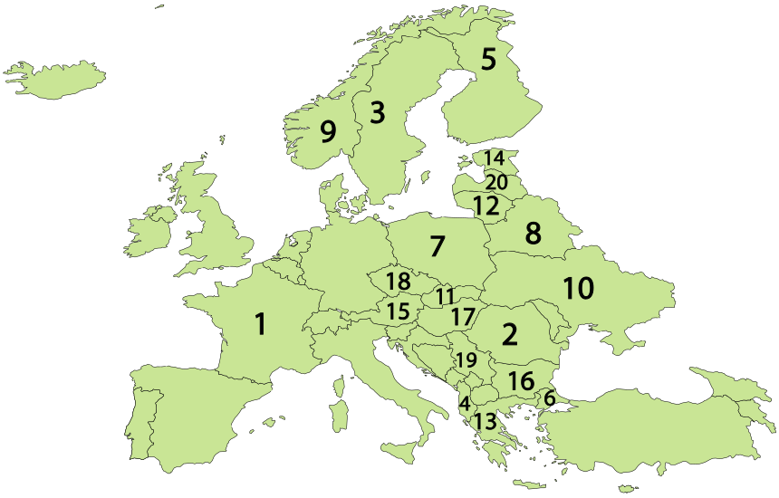
| 1 | France | 6 | Turkey | 11 | Slovakia | 16 | Bulgaria |
| 2 | Romania | 7 | Poland | 12 | Lithuania | 17 | Hungary |
| 3 | Sweden | 8 | Belarus | 13 | Greece | 18 | Czechia |
| 4 | Albania | 9 | Norway | 14 | Estonia | 19 | Serbia |
| 5 | Finland | 10 | Ukraine | 15 | Austria | 20 | Latvia |